
Laser scanning and BIM modeling Services


Marine Survey
Get accurate measurements for repair, retrofits and tank volumes.
Tunnel Surveys
With each scan spanning 1000 Ft and being completed in a few minutes it is very easy to scan long and winding tunnels with incredible density with very limited time.
Bridge Surveys
For movement, assessment and alteration.


Laser scanning for Architectural As built BIM modeling.
Scanning of existing retail spaces for renovations or for new tenants to occupancy. We can laser scan to show structure, heating and electrical components of any type of structure. Accurate digital measurements in 3D can be crucial, when measurements have to be precise. The former Chapters book store at Robson and Howe in Vancouver was scanned and modeled by Laser Geo to enable Sportchek to precisely lay out and configure their furnishings and displays. This saved a huge amount of time and cost by having the interiors built ahead of the store opening. Of course, everything fit perfectly.
Construction Surveys for VDC
The level of detail and precision required in construction creates the perfect opportunity for the application of Laser Scanning. At one construction site where there were curved shapes involved in a facade, LaserGeo was able to scan and model these features in a few visits, while a surveyor had been there for months. To be fair, the surveyed points were accurate, but they could never create enough data to precisely define the complex shapes of the panels. Floor leveling, scanning of rebar before pouring concrete, modeling of ductwork, electrical and structural framing are also services we can provide.
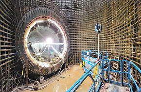
Industrial Laser scanning and 3D modeling-AEC.
Manufacturing plants and refineries, pipelines and transmission lines, marine vessel surveys, hydro dams and draft tubes, pipelines, refineries, transmission lines, marine vessel surveys, complex electrical cabling / infrastructure and substations. You may also want accurate as-built drawings and models. If accuracy is important for your project, don't settle for a tape measure - use our state of the art laser scanning.


Aero Geometrics Ltd. has been at the forefront of mapping technology for over 50 years, evolving from traditional film to advanced digital imagery. Our commitment to accuracy, value, and customer satisfaction remains unwavering as we adapt to the rapid advancements in technology. Once our flight crew captures high-quality imagery, we meticulously process this data, triangulating photos using common reference points. With large projects often involving thousands of high-resolution images, we ensure precise orientation and 3D visualization, delivering exceptional results tailored to our clients' needs.

3D Visualizations!
Using the 3D Point Cloud or model, you can look at the data from any angle. You can also create fly throughs from the data.
From this point, all stereo models can be accurately measured and vector lines can be created to represent planimetric features (roads, buildings, drainage, etc.). A DTM (digital terrain model) is created by capturing break lines and spot elevations which accurately represent the ground surface. This DTM is then triangulated to create a surface mesh which can generate contours at various intervals and can be used to measure piles and calculate volumes.
AeroGeo has many large clients who have used our mapping services since 1975. Ask for some references to understand why the AeroGeo Team places the utmost importance upon our clients’ satisfaction in everything we do.
Aero Geometrics provides complimentary consultation services to align with the specific goals of your organization or clients. We offer basic scanning services and point cloud registration, as well as customized turnkey solutions include CAD drawings and 3D modeling for even the most complex. Our advanced scanners deliver unparalleled accuracy, enabling the documentation of everything from structural movement to the preservation of existing buildings through as-built drawings and detailed 3D models.


LiDAR and photogrammetry are both widely used in visual effects (VFX) and film production because they capture real-world geometry, textures, and environments with a high level of accuracy and realism.
-
Set Scanning / Environment Capture: LiDAR is used to scan film sets, outdoor locations, or even entire cityscapes. The point cloud data provides precise geometry for digital set extensions or recreations.
-
Camera Tracking & Matchmoving: LiDAR scans give accurate spatial references, making it easier to align CG elements with live-action footage.
-
Previsualization: Directors and VFX supervisors can explore scanned environments virtually to plan shots.
-
Digital Doubles of Props: Complex structures (cars, buildings, landscapes) are captured in detail for later integration into CG-heavy scenes.
🔹 Strengths:
-
High accuracy and detail in geometry.
-
Works well in low-light or night shoots.
-
Excellent for large-scale environments.
2. Photogrammetry in VFX
Photogrammetry uses overlapping 2D photographs to reconstruct 3D models with texture information.
🔹 Applications in VFX:
-
Digital Asset Creation: Props, costumes, or even actors can be scanned via photogrammetry rigs (multi-camera arrays) to produce photorealistic digital doubles.
-
Texture Capture: Provides high-resolution, realistic textures for 3D models.
-
Environment Capture: Used for recreating natural landscapes, rock formations, or interiors with high detail.
-
Virtual Production: Often combined with game engines (Unreal, Unity) to quickly build photorealistic environments.


CSI and FORENSICS
All German police have access to 3D Laser Scanners (Z+F) which have been routinely utilized in Europe for many years. Surrey RCMP also recently purchased more than a dozen scanners for their departments. Crime or accident scenes can be captured at the time of an accident and archived for many years. If an item comes up in a courtroom many years later, the archival scan will show the scene to the finest detail and even allow for the measurement between objects, which may be critical to a case.


HERITAGE Building and sites 3D documentation
Create a current as-built drawing where none exists, or when there are concerns regarding structures which may have shifted or settled over time. Once you have documented a building with the Laser scanner, you can easily register all of the scans into a unified point cloud and can accurately measure anything you want with free Z+F software. You can also model the point cloud to create Revit and CAD models and drawings. You now have an accurate as-built drawing of the structure you needed to project and can replicate at anytime.

Aerial LiDAR
LiDAR, originally a portmanteau of "light" and "radar", has now become an acronym for Light Detection and Ranging. This remote sensing technology measures distance by illuminating a surface and measuring distances by analyzing the reflected light. In addition to terrestrial applications, AeroGeo conducts aerial LiDAR surveys with both helicopter and fixed-wing aircraft, and expects to add a LiDAR capable drone in the near future. Drones provide a platform ideally suited for small or time sensitive projects, and allow for a very competitive price structure. Watch for our official roll-out announcement upon completion of rigorous flight and data testing now underway.
Aero Geometrics continues to expand its LiDAR products and services as demand for this exciting technology accelerates. In 2014, AeroGeo flew the entire City of Vancouver (representing approximately 160 square kilometers at a density of ten to sixteen points per square meter), producing a highly accurate data set comprised of billions of points. Call to discuss purchasing this valuable resource (from one to all 160 km2 tiles). AreoGeo again expects a busy season of acquisition as contracts are already signed for projects in 2018 and we are actively quoting on a number of LiDAR surveys.
Perhaps you already have aerial LiDAR, but would like vector data as well? AeroGeo offers vector mapping of planimetric data utilizing stereo LiDARgrammetry. This software enables capturing valuable vector data from LiDAR point clouds. AeroGeo continually develops and evaluates new processing software to automate point classification and feature extraction. We also offer terrestrial LiDAR services for engineering, architecture, industrial and construction applications. Capturing data at 1,000,000 points per second results in projects containing tens of billions of individual XYZ points. Features and structural detail can be modeled to any level of complexity from this incredibly accurate (1-2 mm) data. Aerogeo has recently purchased the first 2016 Z+F scanner in North America. We are also a service center and sales arm for Z+F USA.
Don’t hesitate to reserve your spot in the project queue before resources reach their allocation limits. This is especially important in Northern climates where the acquisition window can be both short and challenging.

AERIAL Mapping & Ground Survey
Aero Geometrics Ltd. provides qualified geomatics experts and equipment to ensure your organization receives unparalleled service and industry leading data accuracy. AeroGeo has completed thousands of Aerial photo sorties throughout Canada and the world over the past four decades. Canadian projects range from B.C. to Newfoundland and include many locations in the Yukon, the Northwest Territories and Nunavut. South and Central America, the USA and Mexico are important areas of operation, with scattered work coming from Africa, Europe and the Middle East.


AeroGeo captures stunning digital imagery in either RGB or RGBI and will fly to provide pixel resolutions of between 5 and 40 centimeters. ABGPS and IMU on the aircraft provide geo-referenced pictures which can then be mosaiced into large, seamless orthophotos. Our software can also display the imagery in stereo and be used to accurately capture planimetric detail, create contours or calculate volumes.
Understandably, many projects require first order survey control in order to properly orient the imagery acquired. Our survey history includes many interesting stories of working in challenging environments and we especially enjoy southern work in our winter months. We possess state of the art GNSS dual frequency receivers and many years of experience conducting drill hole surveys, establishing target coordinates, establishing benchmarks and coordinating local survey points to UTM Nad83, which enables all data sets to be layered together, providing a comprehensive map of existing information.
Call anytime for free consulting advice on your project's requirements. AeroGeo's experts can analyze your goals and customize a solution optimized for your budget, while normally exceeding the required outcomes.
Just ask some of AeroGeo's 50-year clients. Let our experience and our thousands of successful projects work for you.